
Engineering-ready 3D models built from real-world data
Accurate 3D models created from verified laser scan data—used to visualize existing conditions, plan future changes, and coordinate design with confidence.
3D models that reflect reality—and support what comes next
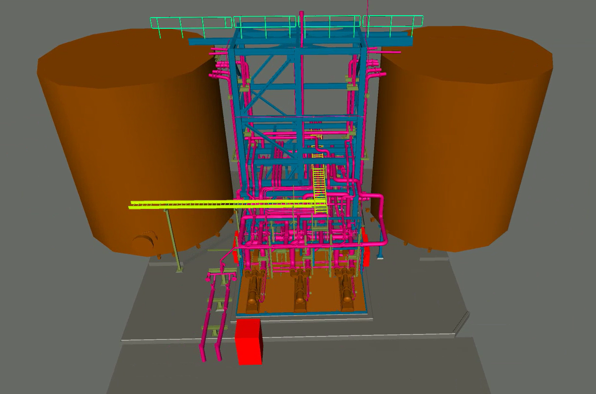
3D modeling transforms captured site data into structured, usable models teams rely on for planning, coordination, and design decisions. Models are built directly from verified laser scan data to accurately represent existing conditions, then structured to support future modifications, equipment integration, and BIM workflows.
Rather than conceptual geometry, these models provide a dependable digital representation of the built environment—allowing teams to visualize constraints, validate fit, and coordinate changes before work begins.
When 3D modeling removes uncertainty
3D models are most effective when teams need a clear, spatial understanding of existing conditions and how proposed changes will interact with the built environment. Whether planning a retrofit, coordinating systems, or evaluating future-state layouts, models provide the context needed to validate fit, identify constraints, and make informed decisions before work begins.
Evaluate how new equipment, systems, or structures fit within existing conditions before installation.
Identify conflicts, access limitations, and tight clearances in complex or constrained environments.
Provide engineers and architects with an accurate digital baseline to design against.
Model proposed layouts and changes to support planning, review, and stakeholder alignment.
Deliverables from 3D modeling
Structured, design-ready models built from verified existing conditions.
As-built 3D models (CAD / BIM)
Accurate 3D representations of existing conditions modeled from reality capture data, suitable for design, coordination, and planning.
Discipline-specific models
Models developed to match project needs—architectural, structural, mechanical, electrical, piping, or equipment—without unnecessary geometry.
Design-ready geometry
Clean, organized models built to support downstream workflows such as layout planning, system integration, and constructability review.
Future-state and proposed-condition models
Optional modeling of new equipment, layouts, or modifications to evaluate fit, clearances, and sequencing before installation.
Clash and clearance analysis
Identification of spatial conflicts, access constraints, and tight tolerances using modeled geometry aligned to real-world conditions.
Standard file formats for your tools
Models delivered in formats compatible with common CAD, BIM, and coordination platforms used by engineering and construction teams.
From captured reality to usable 3D models
We follow a disciplined workflow to ensure 2D drawings accurately reflect real-world conditions. Each phase is designed to eliminate assumptions, reduce rework, and deliver drawings your team can trust.
Scope and drawing definition
We align on how the model will be used—design, coordination, retrofit planning, or visualization—so the level of detail, disciplines, and outputs match the project’s needs.
Model from verified existing conditions
Our team builds 3D models directly from registered point cloud data, ensuring geometry reflects real-world conditions rather than assumptions or legacy drawings.
Review, validate, and deliver
Models are checked for accuracy, consistency, and usability before delivery in standard formats ready for engineering, coordination, or planning workflows.
Outcomes enabled by accurate 3D models
Field-verified 3D models reduce uncertainty, improve coordination, and allow teams to plan changes with confidence—before work begins.
Validate fit before installation
Confirm that new equipment, systems, and structures will fit within existing conditions—eliminating surprises during construction or retrofit.
Resolve conflicts earlier
Identify clashes, clearance issues, and access constraints digitally, where changes are faster and far less expensive to resolve.
Align stakeholders visually
Provide a shared, accurate model that engineers, owners, contractors, and operators can review, reducing misinterpretation and rework.
Plan future changes with confidence
Use accurate existing-condition models as a trusted baseline for future expansions, modifications, and long-term facility planning.
Start with accurate data you can trust
Talk with our team about your facility, scope, and objectives to determine the right capture, modeling, and analysis approach.