


When a project depends on existing conditions, the first question is rarely, “What model do we need?”
It is usually, “Can we trust the starting data?”
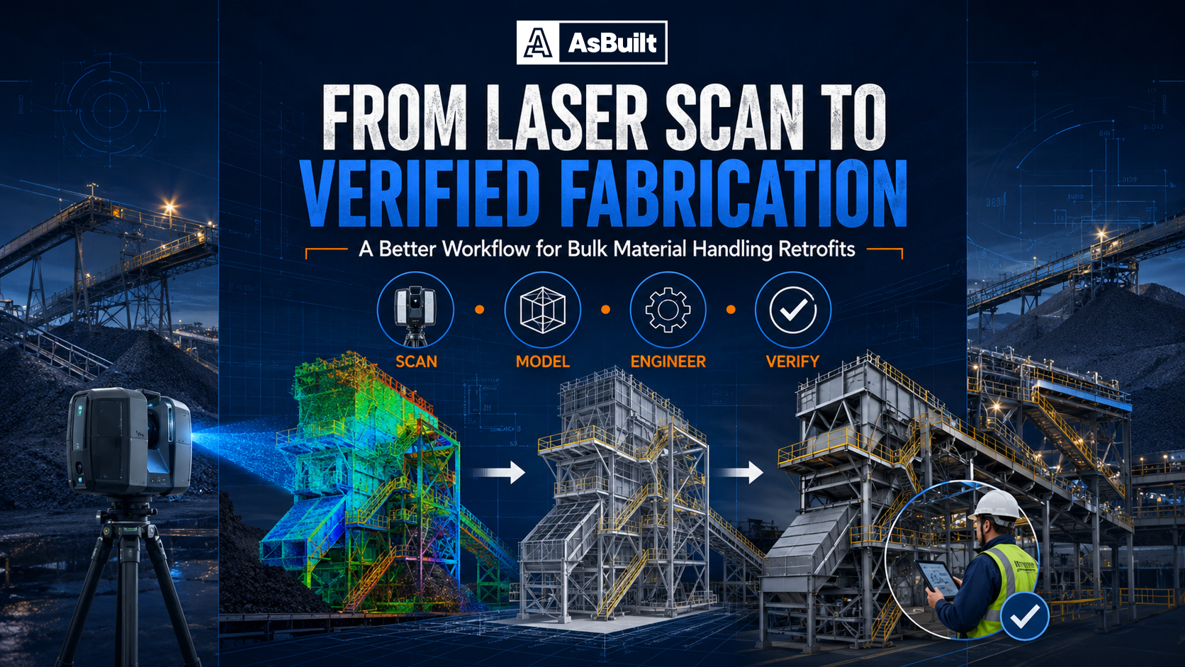
That question matters most in industrial plants, power facilities, manufacturing environments, and complex commercial retrofits where outdated drawings, undocumented changes, and limited access can turn a simple design task into a costly field problem. AsBuilt’s core value proposition is built around solving exactly that problem with field-verified data, as-built drawings, 3D models, and scan-based analysis for design, coordination, fabrication, and execution.
Today, project teams have more capture options than ever. Terrestrial laser scanning, SLAM mobile scanning, photogrammetry, and Matterport-style digital twins all promise faster documentation and better visibility into the field. But they are not interchangeable.
The right answer is usually not “pick one technology.”
It is “pick the right workflow for the risk.”
Reality capture tools optimize for different outcomes. Some are built for millimeter-level confidence. Others are built for speed, coverage, or easier collaboration. If you choose the wrong method for the job, you may still get a visually impressive deliverable, but not one you can safely use for tie-ins, clash-sensitive design, prefabrication, or construction verification. That distinction is central to industrial and retrofit work, where AsBuilt emphasizes engineering-ready outputs rather than scanning for its own sake.
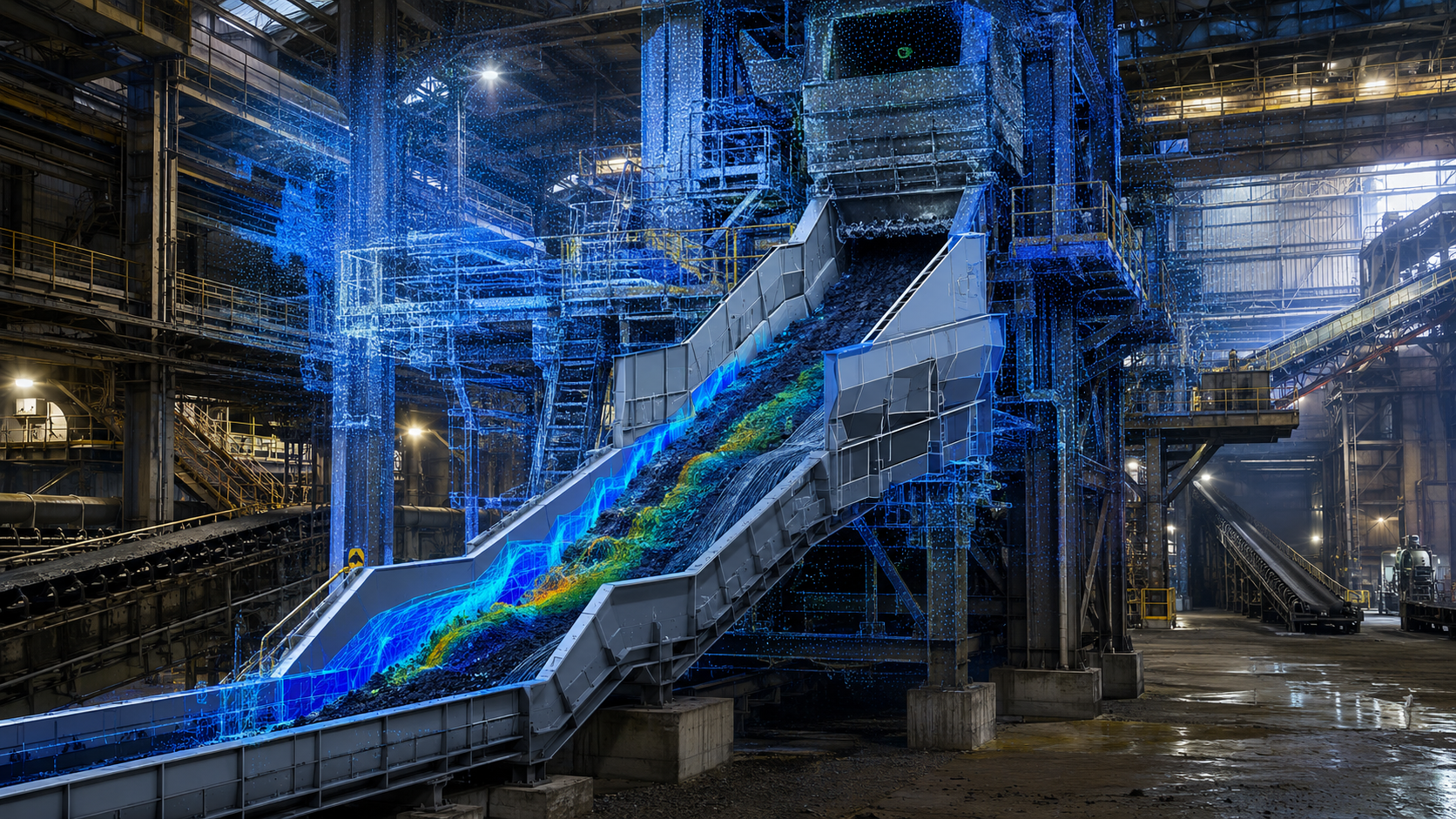
Terrestrial laser scanning uses a tripod-mounted scanner to capture dense, highly accurate point cloud data from fixed positions. This is the method most teams think of when they hear “3D laser scanning.”
For projects where geometric certainty matters most, TLS remains the strongest option. It is especially effective for:
Current mainstream TLS platforms are generally marketed in the millimeter to low-single-digit-millimeter range, which is why they remain the conservative choice when decisions carry schedule, fabrication, or safety risk.
Where TLS wins
Where TLS struggles
For industrial owners, EPCs, and contractors, TLS is often the anchor dataset when the consequences of being wrong are expensive.
SLAM-based mobile scanning uses LiDAR, IMU, and increasingly camera-based inputs to capture data while the operator walks through a facility. It is dramatically faster than tripod-based scanning for large interiors and active facilities.
That speed makes SLAM attractive for:
But SLAM accuracy is more dependent on environment and workflow. Drift, route design, loop closure, feature richness, and control points all affect results. In practice, SLAM is powerful, but it is best treated as a fast-capture tool that often benefits from TLS in critical areas.
Where SLAM wins
Where SLAM struggles
For many industrial workflows, SLAM is not a replacement for TLS. It is a productivity layer that makes the full capture strategy more efficient.
Photogrammetry reconstructs geometry from overlapping images rather than directly measuring with a laser. In industrial and construction settings, it is often delivered through drone-based capture, though close-range terrestrial workflows also exist.
Photogrammetry is strongest when the project needs:
Its biggest advantage is economic coverage. It can document large exteriors quickly and cost-effectively, especially when paired with RTK, PPK, or control. But it is much less dependable in dark, cluttered, reflective, repetitive, or texture-poor interiors like pipe racks, process areas, and equipment-dense plants.
Where photogrammetry wins
Where photogrammetry struggles
For most industrial firms, photogrammetry works best as a complement to laser scanning, not a replacement for it.
Matterport-style systems occupy a different category. They are optimized for speed, simplicity, cloud processing, remote access, and stakeholder-friendly walkthroughs.
That makes them useful for:
But these systems are not designed to be the safest default for precision engineering. Their value is ease of use and accessibility, not millimeter-critical verification. For teams that need immediate collaboration and a highly navigable model, they can be extremely useful. For fit-up, fabrication, and tie-in design, they should be used with care.
Where Matterport wins
Where Matterport struggles
This distinction matters because visually impressive models can create false confidence if the downstream use case demands more rigor than the capture method was designed to provide.
For engineering use, the practical hierarchy is usually:
TLS first, then best-in-class SLAM, then controlled photogrammetry, then Matterport-style systems for context-heavy but less deterministic geometry.
That does not mean every project needs TLS everywhere. It means the more the project depends on exact geometry, the more conservative the capture method should be.
A helpful way to think about it:
Manufacturing environments often need a hybrid workflow. Teams may need rapid context for layout planning, plus precise geometry at machine interfaces, overhead utilities, and installation zones.
A practical strategy is:
This matches AsBuilt’s industrial positioning around accurate starting conditions, design-ready models, and reduced risk in upgrades and relocations.
Power, utility, and process environments usually put the highest value on trustworthiness of geometry. Pipe routes, vessel clearances, tie-ins, and structure interfaces leave less room for assumptions.
A strong workflow is:
This is highly consistent with AsBuilt’s messaging for power and utility work, where documentation accuracy directly affects risk, outages, and execution.
Commercial teams often balance speed against trust. Weekly progress documentation, owner communication, and remote reviews may not require the same rigor as final verification or clash-sensitive coordination.
A typical approach is:
The most effective reality capture programs are increasingly hybrid. That is one of the clearest conclusions from the source report.
Instead of asking which technology is “best,” a better question is:
Which combination gives the project the right balance of certainty, speed, coverage, and usability?
A few examples:
Before selecting a technology, ask these questions:
Do you need a point cloud, 2D as-built drawings, a BIM model, a coordination model, a digital twin, or scan-based verification?
Is the data supporting walkthroughs and planning, or fabrication, clash detection, and installation?
Is the scope mainly interior, exterior, roof, yard, equipment area, or tie-in zone?
Some workflows are better suited to active operations and tight access windows.
Engineers, contractors, operations teams, and executives often need different outputs from the same capture effort.
This consultative planning approach mirrors how AsBuilt frames project scoping: define what needs to be captured, why the data is needed, how it will be used, and what conditions govern access and execution.
AsBuilt is positioned around accurate existing-condition data for industrial and complex facilities, with services that extend beyond capture into 2D documentation, 3D modeling, BIM coordination, scan-based analysis, reverse engineering, fabrication verification, and management of change. That makes AsBuilt especially well suited for projects where the objective is not just to collect data, but to turn reality into decisions the project team can actually use.
There is no single capture method that wins every project.
For industrial, utility, manufacturing, and retrofit work, the best production workflow is often a mix of technologies guided by risk, deliverables, and downstream use. The goal is not to collect more data. The goal is to start with reality and build with confidence.
If your project depends on knowing what truly exists before design, coordination, or construction begins, AsBuilt can help define the right capture strategy and turn the results into engineering-ready deliverables. Contact us to learn which type of scanning technology is best for your project.

Each project represents our commitment to accuracy and technical excellence


Talk with our team about your facility, scope, and objectives to determine the right capture, modeling, and analysis approach.